Getting Acquainted with the Middle East
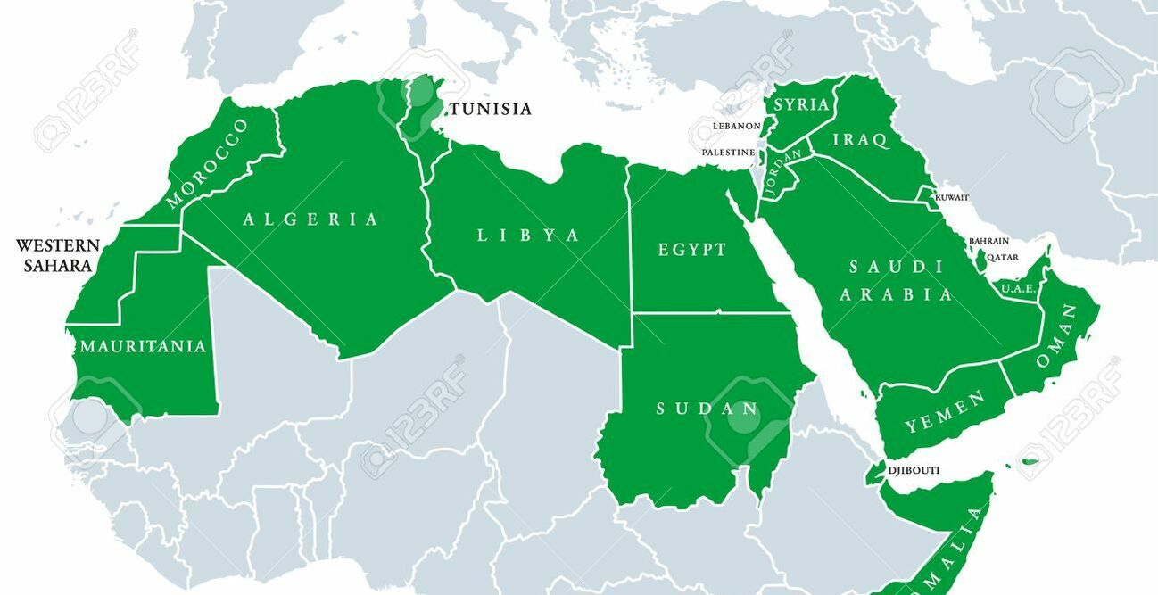
Somewhere on a continent far, far away, a cartographer grappled with the term Middle East. This cartographer had to consider how other cartographers, scholars, journalists, and politicians used the term, and that wasn't easy. Often the Middle East refers to part of the Arab World as far west as Egypt, as far east as Iran, and as far north as Turkey. Because the rest of the Arab World (Morocco, Algeria, Sudan, Tunisia, and Libya) is in North Africa, some people employ the term MENA (Middle East North Africa). Others coin the term the Near East (as opposed to the Far East) to cover this region, and toss in Afghanistan for good measure. This term (Near East) didn't really catch on in the media, so today scholars and political analysts are just about the only ones who use it.
To simplify, others stubbornly just use the Middle East to refer to all those countries and sometimes lump in Pakistan because it's culturally, politically, and religiously linked. Some people argue that Afghanistan and Pakistan don't belong on the indistinguishable Middle East's map (and that strictly speaking they belong on the map of Central and/or South Asia). But nowadays, more and more people equate these two countries with the Middle East. Since September 11, 2001, separating Afghanistan and Pakistan from the Middle East has been increasingly difficult.
For the purposes of definition, the Middle East stretches from Morocco in the west to Pakistan in the east. The Middle East extends to Turkey in the north and Yemen, Somalia, and Sudan in the south.
Identifying the Countries, the Land and the Climate
|
When you think of the Middle East, you probably think of sand dunes, flat-roofed mud houses clustered in a desert, and minarets rising out of a dry, dusty Egyptian city. Well, all that exists, but the Middle East is a little more diverse. Take a look!
From the earliest civilizations, dating back thousands of years before the Common Era (a euphemism for the era formerly known as A.D.), people typically lived near sources of water, usually rivers. Even today, in the age of desalinization plants and sophisticated underground water systems, the Middle East's survival depends on rivers and other natural sources of water. The Arab World stretches from Morocco in the west to Iraq in the east, and from Syria in the north to Yemen in the southern Arabian Peninsula, encompassing 17 countries: Algeria, Bahrain, Egypt, Iraq, Jordan, Kuwait, Lebanon, Libya, Morocco, Oman, Qatar, Saudi Arabia, Sudan, Syria, Tunisia, the United Arab Emirates, and Yemen. You can throw in Palestine although it's not yet an independent country. |
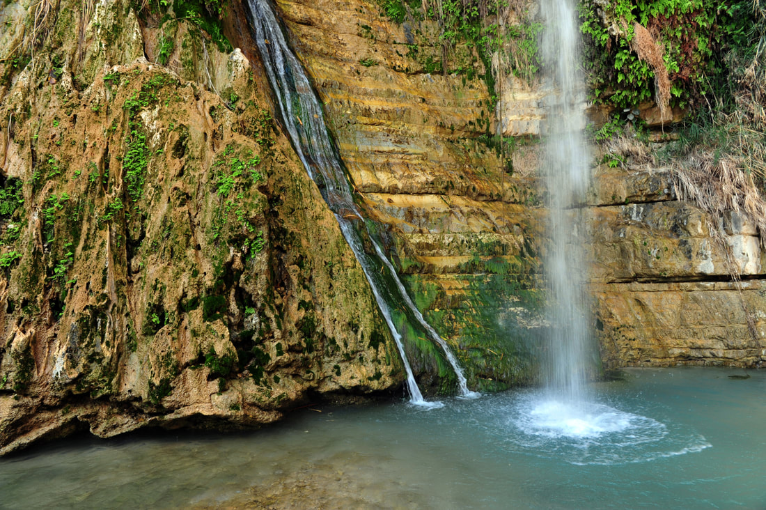
Ein Gedi Natural Reserve
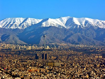
Elburz Mountains
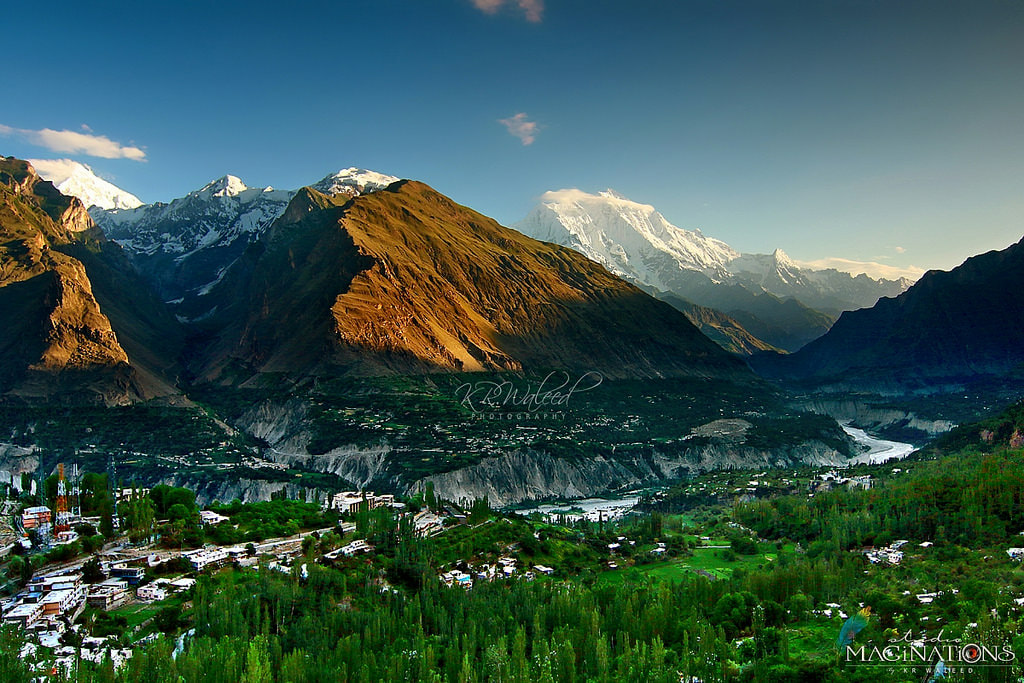
Hunza Valley
|
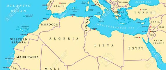
North Africa
North Africa runs from the Atlantic Ocean at Mauritania, along the Mediterranean Sea, and across the Nile River to the Red Sea. Mauritania, Morocco, Algeria, Tunisia, Libya, Egypt, and Sudan comprise North Africa. The Sahara Desert stretches across most of North Africa. Sand dunes occupy about 15 percent of the Sahara, while huge bare plateaus of stone cover 73 of the desert. Temperatures are hot, and the climate is dry. With the exception of Morocco, which has 18 percent arable land, less than 5 percent of the soil in North Africa is tillable. The Atlas Mountains stretch from Morocco through Algeria and into Tunisia. The northern slopes of these mountains form flowing river basins that produce fertile farmland and forests and allow for irrigation. In Morocco, for instance, the majority of the population lives in the Atlas Mountains foothills and farms the fertile plains, valleys, and plateaus between the mountains and the coast.
More than 90 percent of Egypt is barren desert. The Nile River sustains life in the desert throughout Egypt and parts of the Sudan. The Nile also provides hydroelectric energy. The Sinai Peninsula is east of the Nile, with Mount Katherine and Mount Sinai at the peninsula's center. Egypt is hot and dry, and even in the winter, average temperatures are about 70 degrees in the day. Some parts receive almost no rainfall, while Alexandria boasts a whopping seven inches a year.
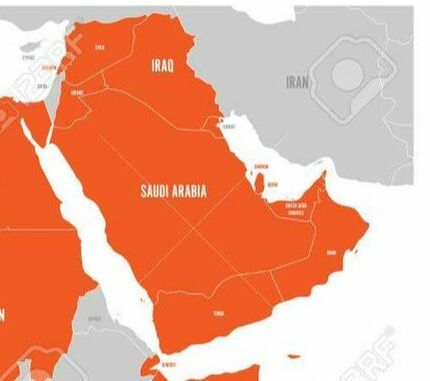
The Arabian Peninsula
Three bodies of water — the Red Sea to the west, the Persian Gulf to the east, and the Arabian Sea to the southeast — surround the Arabian Peninsula. The climate is mostly a harsh, dry uninhabitable sandy desert. Temperatures exceeding 120 degrees from May to September aren't out of the ordinary. Rub al-Khali Desert (or the Empty Quarter) occupies the northwest region and receives almost no rainfall at all compared to other parts that receive six inches per year. Had it not been for the famous well of Zam Zam, the holy city of Mecca could never have sustained life.
A host of smaller Gulf States line the periphery of the peninsula: Bahrain, Qatar, and the United Arab Emirates. Oman and Yemen eclipse a significant portion of the Arabian Peninsula's southern tip. Jordan and Iraq lie to the north of the peninsula. Farmers can work very little of the peninsula, and most of the nations rely on petroleum production. The Asir Mountains run along the southwestern coast of Saudi Arabia and receive 25 times the national average rainfall. The Jebel Akhdar Mountains are a luscious green contrast to the peninsula's overwhelming barrenness. The fertile Batinah Plain runs near Muscat, while the Salalah Plain in the south near Dhofar is a lush semitropical area as a result of the summer monsoon lasting from June to September.
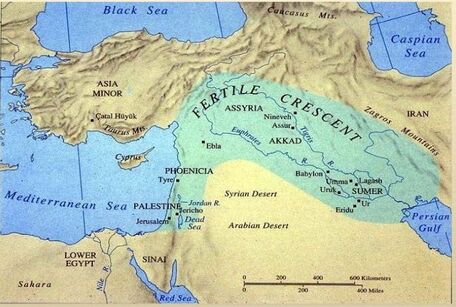
The Fertile Crescent
The Fertile Crescent runs from the Mediterranean Sea along the coast of Israel, Lebanon, and Syria across the Rift Valley through Jordan and over to the Tigris and Euphrates rivers in Iraq in the east. In the summer, the coast-line is hot and balmy, and in the winter, rain and snow can fall in Palestine and Israel. The bulk of the region from the Negev and Judean deserts in southern Israel across the Dead Sea and the Jordan Valley reaching into Iraq is hot and dry. About 17 percent of Israel's and Palestine's land is arable, primarily in the north, which receives more rainfall and where you can find a wide range of wildlife. Nestled in the Lebanon Mountains, the Cedars is the famous winter resort where snowfall is so abundant that the French set up a ski resort in the 1930s. After World War 11, Lebanon earned a reputation as The Switzerland of the Middle East.
The Jordan, Tigris, and Euphrates rivers have sustained life in Jordan and Iraq for thousands of years. Very little of Jordanian land and only about 12 percent of Iraqi land can be farmed. Although most of Syrian territory is semi-arid and desert plateau, about a quarter of the land is used for agriculture. The Anti-Lebanon Mountains create a natural border between Lebanon and Syria, just as the Zagros Mountains and the Shatt al-Arab waterway do between Iraq and Iran.
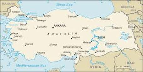
Anatolia
Rising north from Syria is the Anatolian Plateau, which is home to modern-day Turkey. This country extends from Greece and the Mediterranean Sea in the west and southwest, to a narrow strip bordering Bulgaria in the north-west, and to the Black Sea in the north. Turkey borders Armenia and Iran in the east. The terrain and climate contrast the Middle East's other dry desert regions. Turkey has sprawling plains, thick forests, rolling steppes, tall moun-tains, and powerful rivers and streams. More than a third of the territory is arable. Assorted wildlife is native to Turkey. The winters can be cold with considerable snow in the mountains. Summers are cool on the Black Sea coast and on the Anatolian Plateau but extremely hot in the country's south-east region.
Rising north from Syria is the Anatolian Plateau, which is home to modern-day Turkey. This country extends from Greece and the Mediterranean Sea in the west and southwest, to a narrow strip bordering Bulgaria in the north-west, and to the Black Sea in the north. Turkey borders Armenia and Iran in the east. The terrain and climate contrast the Middle East's other dry desert regions. Turkey has sprawling plains, thick forests, rolling steppes, tall moun-tains, and powerful rivers and streams. More than a third of the territory is arable. Assorted wildlife is native to Turkey. The winters can be cold with considerable snow in the mountains. Summers are cool on the Black Sea coast and on the Anatolian Plateau but extremely hot in the country's south-east region.
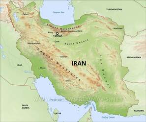
Iranian Plateau
The Zagros Mountains and the Shatt al-Arab waterway in western Iran form a natural border with Iraq. The Elburz Mountains in the north run along the Caspian Sea. Iran shares northern borders with Turkmenistan east of the Caspian and Azerbaijan west of the Caspian. The eastern Iranian frontier runs adjacent to Afghanistan and Pakistan. The Persian Gulf flanks Iran to the south. Although the Caspian coast is subtropical, as a result of heavy rain and snowfall on the northern slope of the Elburz, Iran is mostly arid. Much of Iran's terrain is dry, particularly its two massive deserts — Dasht-i Kavir and Dasht-i Lut — which lie in the eastern and northeastern regions of the coun-try. Iran can be cold in the winter, although summers can reach 105 degrees in the southwest. Iran's oil reserves are significant, but only about 10 percent of the land can be farmed.
The Zagros Mountains and the Shatt al-Arab waterway in western Iran form a natural border with Iraq. The Elburz Mountains in the north run along the Caspian Sea. Iran shares northern borders with Turkmenistan east of the Caspian and Azerbaijan west of the Caspian. The eastern Iranian frontier runs adjacent to Afghanistan and Pakistan. The Persian Gulf flanks Iran to the south. Although the Caspian coast is subtropical, as a result of heavy rain and snowfall on the northern slope of the Elburz, Iran is mostly arid. Much of Iran's terrain is dry, particularly its two massive deserts — Dasht-i Kavir and Dasht-i Lut — which lie in the eastern and northeastern regions of the coun-try. Iran can be cold in the winter, although summers can reach 105 degrees in the southwest. Iran's oil reserves are significant, but only about 10 percent of the land can be farmed.
Afghanistan and Pakistan
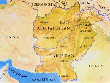
Afghanistan and Pakistan pick up in the west where Iran leaves off. Southwestern Afghanistan is flat and dry, and gives way to the Hindu Kush Mountains occupying most of the remainder of the country. These mountains became famous after 2001 as U.S.-led coalition troops conducted operations against the Taliban and Al-Qaeda forces holed up in sophisticated caves designed with elaborate ventilation systems and generators for electricity. The mountainous region is cool in the summer and extremely cold in the winter. Some regions receive heavy snowfall. Afghanistan shares a border with Turkmenistan, Uzbekistan, and Tajikistan in the north, Pakistan in the south, and a small sliver of China in the east. About 12 percent of the land is arable.
Don't think about traveling alone through Pakistan's western no-man's lands! Extending eastward from the Iranian border are the inhospitable climates of Baluchistan and the Makran coast, where Alexander the Great's army was nearly decimated by the brutal heat and aridity. The Indus River and its five famous river tributaries (Jhelum, Chenab, Ravi, Sutlej, and Beas) offset the bulk of Pakistan's dry and flat terrain, giving the region of the Punjab (five rivers) its name. These rivers flow southwest and have provided life for millennia. Originating high in the mountains of eastern Pakistan near the border with China, these five rivers help to make 28 percent of Pakistan's land farmable. India and the Arabian Sea delineate the southeastern border of Pakistan.